SoCal Boater's Guide
Shipping calculated at checkout
In stock
The Private Boater's Guide to Fishing and Diving in Southern California
Updated for 2023 with 50 Fathom Rockfish Boundary waypoints! This is our flagship product, featuring 18 detailed fishing and diving maps of Southern California's coastline from Point Conception to Ensenada. This map guide contains a wealth of local knowledge for the So Cal private boater, no matter which harbor you call home.
Follow the Bite, All Over the Bight
It has never been more possible for the So Cal angler to stay on the fish up and down the coast. Hot bite for bluefin out at the 43 Fathom Spot? Or maybe the backside of Catalina's on fire for seabass. How about the killer rockfishing all the way out at San Nic? No excuse now, you know where to go. And where not to.
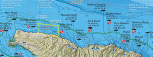
Map Titles
Includes 18 map titles covering the entire Southern California coastline:
- Channel Islands Offshore
- Santa Barbara Channel
- SoCal Bight Offshore
- Santa Monica Bay
- Palos Verdes
- San Pedro Shelf
- Horseshoe Kelp
- Long Beach Harbor
- Catalina Island
- Huntington Flats
- Newport Reefs
- Laguna Coast
- South Orange County
- San Clemente Island
- San Diego Offshore
- North County
- San Diego Local
- San Diego Borderlands
Find Your Next Hot Fishing Spot
Our fishing and diving maps are more than just GPS numbers. We also include fish-holding habitat like kelp beds, rocky reefs and hard bottom areas, eelgrass, docks and artificial reefs, so you can find your next hotspot off the beaten path.
Fish with Confidence
We also show fishing regulation boundaries like the new 50-fathom rockfish depth limit, 40-fathom fishing boundaries within Cowcod Conservation Areas, Marine Protected Area GPS boundaries and rule summaries, as well as local "no fishing" or "no diving" zones closer to the harbor. Fish and dive with confidence with our Southern California Boater's Guide!
Over 1000 Popular Fishing and Diving Spots With GPS
GPS numbers listed for over 1000 popular fishing and diving spots along the Southern California coastline, including: Gaviotas, Tajiguas, Naples Reef, Ellwood, More Mesa, Mohawk Reef, 12 Mile Reef, Camby's Reef, 4 Mile Reef, 1 Mile Reef, Dulah Reef, Ventura Flats, Wilson Rock, Westcott Shoal, Wyckoff Ledge, Rodes Reef, Bee Rock, Eagle's Nest, Santa Rosa Pinnacles, Becher's Bay, Christy's, Beacon Reef, Chinese Harbor, Anacapa Gap, Gull Island, Blue Banks, Coches Prietos, Yellowbanks, Pink Ribbon, Flame Reef, The Towers, Coral Reef, Footprint Reef, Arch Rock, Cat Rock, Anacapa Landing Cove, Potato Bank, Cherry Bank, Tanner Bank, The Snail, Osborn Bank, Kidney Bank, Hidden Reef, The Boot, Farnsworth Bank, Avalon Bank, The Slide, 14 Mile Bank, Mackerel Bank, San Clemente Canyon, 30 Mile Bank, 43 Fathom Spot, Ventura County Line, Harrison's Reef, Leo Carillo, Decker Canyon, Pt Dume Pinnacles, Big Kelp Reef (BKR), Paradise Cove, Escondido Beach, Latigo Reef, Corral Beach Reef, Pepperdine, Colony Kelp, Malibu Kelp, Malibu Rockpile, Rockhouse Reef, Carbon Beach, Malibu Artificial Reef, Las Flores Kelp, Big Rock, Burnt House, Topanga Bubbles, Temescal, Long Wharf, Star of Scotland Wreck, Santa Monica Artificial Reef, Twin Towers, Ocean Park, Short Bank, South Bank, Volcanic Reef, Palawan Wreck, Malaga Cove, Bit Rock, Haggerty's Crane, Bay Junk, Rocky Point, Seabass Rock, Christmas Tree Cove, Pt Vicente, Marineland, Beanies, Portugese Point, Cherry Tree, K.O.U. Rock, Royal Palms, Whites Point, Pagoda Rock, Whites Point, Point Fermin, Horseshoe Kelp, The Rockpile, Red Tank, Middle Grounds, Olympic II Wreck, Southeast Rock, 14 Minute Wreck, Potter's Reef, High Kelp, White Spot, 105 Area, 150 Kelp Reef, Double Rigs Reef, Mussel Farm, Newport Pipe, The BTR, Huntington Flats, Ribbon Kelp, Miniature Rock, Huntington Reefs, Newport Reef, Izor's Reef, Newport West Jetty Reef, Newport Canyon, Pelican Point, Reef Point, Abalone Point, Laguna Pinnacles, Deadman's Reef, Shaw's Cove, Las Brisas, Middle Kelp ReRock Wall, Treasure Island, 1000 Steps Reef, Aliso Pipe, Monarch Boilers, Salt Creek, San Juan Boilers, Dana Canyon, Dana Barber Poles, Clemente Reef, Trestles Kelp, The Domes, Box Canyon, Patterson Kelp, Yellowtail Kelp, Barn Kelp, 12 Foot Rock, Clam Beds, The Golf Ball, Buccaneer Pipe, Carlsbad Kelp, Otto's Hole, Leucadia Kelp, Stonesteps, Swami's, Cardiff Pipe, Table Top Reef, Del Mar Kelp, Powerhouse, Flat Rock, The Bump, The Half, 3/4 Spot, NW Corner, Variety Kelp, USS Yukon Wreck, Jetty Kelp, The 270, Hill Street, The College, Green Tank, The Lab, 5 Tanks, Dolphin Tanks, Ancient Sea Cliffs, The Whistler, Lighthouse Ridge, IB Flats, IB Kelp, Hogan Wreck, Tijuana Flats, Bull Ring, Las Playas, The Keyhole, Coronados Middle Grounds, Pukey Point, 5 Minute Kelp, SKR, The Rockpile, the 425, The 302, Cortes Bank, Mushroom Bank, 60 Mile Bank, The Worm, The Pistol, The Airplane, 1010 Trench, The Double 220, Hidden Bank, San Salvador Knoll, Banda Bank and much more!