San Diego Local / SD Borderlands
Shipping calculated at checkout
In stock
San Diego Local / SD Borderlands
This 2-sided laminated map shows the GPS locations of popular inshore fishing and diving spots along the San Diego coastline, including the La Jolla Kelp, Point Loma Kelp, the Coronado Islands and the Rockpile.
Two Maps in One!
Includes 2 map titles, printed back to back: San Diego Local and San Diego Borderlands, both also found in our Private Boater's Guide to San Diego County.
Side 1 of this laminated map covers the fishing spots along the San Diego coastline from Scripps Pier to Ballast Point. Fishing "local" in San Diego means fishing La Jolla or Point Loma and we've got you covered with over 60 GPS locations of popular fishing spots up and down the kelp line. Includes inset maps of the Pacific Beach and Mission Bay Park artificial reefs. This fishing map is current for 2021 with SoCal's 100-Fathom rockfish depth boundary.
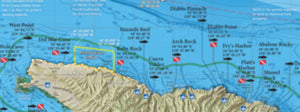
Side 2 of this laminated map covers the San Diego coast near the Mexican border, from Mission Bay south to Popotla in northern Baja. Shows the GPS location of popular inshore fishing and diving spots south of San Diego Bay including the Pt Loma Kelp, IB Kelp, Coronado Islands and The Rockpile. Includes inset map of International Reef. This fishing map is current for 2021 with SoCal's 100-Fathom rockfish depth boundary.
Fishing Habitat
Yellowtail, calico bass, white sea bass, halibut, sand bass, sculpin, rockfish, lobster...our maps show the fish-holding habitat that an inshore fisherman needs-to-know: rocky reefs, kelp, boiler rocks, jetties, wrecks, artificial reefs and all with a calibrated GPS grid overlay so you can pinpoint your next favorite honey hole!
Over 100 Popular Fishing and Diving Spots
GPS numbers listed for over 100 popular fishing and diving spots along the San Diego coastline, including: Torrey Pines Artificial Reefs, Scripps Canyon, Quast Rock, God's Rock, the Bump, The Half, 3/4 Spot, The 10, Horseshoe Reef, Round Kelp, NW Corner, The 32, The 270, Widow Rock, Jetty Kelp, SW Corner, Bird Rock, Variety Kelp, USS Yukon, Round House, The Pine Tree, Hill Street, The College, Green Tank, The College, Goal Posts, The Lab, 3 Finger's Reef, 5 Tanks, Dolphin Tanks, Ancient Sea Cliffs, The D.O., Train Wheels, The Whistler, Zuniga Jetty, the Sub Wreck, IB Flats, IB Pipe, Sloughs Kelp, USS Hogan Wreck, International Reef, the Bull Ring, Tijuana Kelp, Las Playas Kelp, The Waterfall, Pukey Point, Ribbon Kelp, the Middle Grounds, Coronados White Rock, Coronados Bull Kelp, SKR, 5-Minute Kelp, The Rockpile, The Smokestack, the 9-mile Bank, the 101, 425 and much more!