Channel Islands Boater's Guide
In stock
The Private Boater's Guide to the Channel Islands
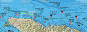
New for 2022! Introducing fishing and diving maps of the individual Channel Islands, from San Miguel to San Nic and all areas in between. This 8-page map guide contains a wealth of information for every private boater venturing to the Islands, whether fishing, diving or just plain cruising.
We show fishing regulation boundaries like the 100-fathom rockfish depth limit, 40-fathom fishing boundaries within Cowcod Conservation Areas, Marine Protected Areas and rule summaries, as well as anchorages, public piers and landings, popular dinghy landings on the beach and much more. Fish and dive with confidence with our Channel Islands Boater's Guide!
Map Titles
Includes the following map titles:
- San Miguel Island
- Santa Rosa Island
- Santa Cruz Island
- Anacapa Island
- Santa Barbara Island
- San Nicolas Island
- Channel Islands Offshore
Local Boating Knowledge
San Miguel, Santa Rosa, Santa Cruz, Anacapa and Santa Barbara islands are owned by the National Park Service and are open to the public to landing on the island. Facilities include campgrounds, ranger stations, visitor centers, fresh water sources, public piers, day-use areas, medical aid and hiking trails. We also include popular anchorages and dinghy landings so you can have the confidence to explore on your own terms. We print each island's landing procedures and emergency contacts right on the map to make your visit as simple as possible.
Navy Restrictions at San Nic
San Nicolas Island is owned by the US Navy and has various rules and regulations a private boater must follow: a 300-yard buffer around the island closed to vessel entry, Restricted Areas A, B, C that close to vessel traffic for military exercises, and a Restricted Anchorage at the East End of the Island. We have all the information you need to navigate around these restrictions, printed right on the map!
Over 200 Popular Fishing and Diving Spots at the Channel Islands
GPS numbers for over 200 popular fishing and diving spots at the Channel Islands are included in The Private Boater's Guide to the Channel Islands, such as:
Wilson Rock, Westcott Shoal, Wyckoff Ledge, Miracle Mile, Rain Barrel, SE Bluffs, Lover's Cove, Prince Island, Egg Rock, Aggi Wreck, Talcott Shoal, Santa Rosa Reef, Bee Rock, Cluster Point, Jolla Vieja, Eagle's Nest, Rodes Reef, Beacon Reef, Santa Rosa Pinnacles, Becher's Bay, West End Ridge, Potato Patch, Christy's, Kinton Point, Willows, Chinese Harbor, Gull Island, Blue Banks, Coches Prietos, Yellowbanks, Pink Ribbon, Flame Reef, The Towers, Coral Reef, Footprint Reef, Arch Rock, Cat Rock, Anacapa Landing Cove, San Nic East End Buoy, East End, Seabass Rock, East End Squid Beds, Airplane Rock, Blockhouse Reef, Three Mile Reef, Alpha Kelp, Thousand Springs, The Boilers, 7 Fathom Reef, Rock Crusher Reef, West End Reef, The Wreck, The Markers, Dutch Harbor, Daytona Beach, SBI's Cat Canyon, Sutil Island, Three Sisters, Signal Boilers, Websters, Caverns, Arch Reef, Elephant Seal Cove, Shag Rock, Arch Point, Landing Cove, Ranger Point, Cave Canyon Squid Beds, Sea Lion Rookery, SE Reef and much more!