Orange County Boater's Guide
In stock
The Private Boater's Guide to Orange County
Introducing detailed fishing and diving maps of Orange County's coastline from Seal Beach to San Onofre and all areas in between. This map guide contains a wealth of information for the private boater hailing from Huntington, Newport or Dana Point Harbors.
Our fishing and diving maps are more than just GPS numbers. We also include fish-holding habitat like kelp beds, rocky reefs and hard bottom areas, eelgrass, docks and artificial reefs, with a calibrated GPS grid overlay so you can pinpoint your next hotspot off the beaten path.
Map Titles
Includes the following map titles:
- So Cal Inner Banks
- Huntington Flats
- Newport Reefs
- Newport Harbor
- Laguna Coast
- South Orange County
- Huntington Harbour
Artificial Reef Maps
Artificial reef maps include Izor's Reef, the Huntington Beach Artificial Reefs, Newport Reef, Wheeler North Reef and Pendleton Reef. All artificial reef maps feature hi-def shaded relief, hard bottom and a calibrated GPS grid so you can pinpoint any spot on the map.
Local Boating Knowledge
In addition to fishing regulation boundaries like the new 100-fathom rockfish depth limit, Marine Protected Areas and rule summaries, our maps offer local boating knowledge closer to the harbor. We even have the new public boating channel to Huntington Harbour on our map, which opened in January 2021. Fish and dive with confidence with our Orange County Boater's Guide!
Small Craft Harbor Facilities
Our bay maps Huntington Harbour, Newport Harbor and Dana Pt Harbor show small craft harbor facilities like marinas, fuel docks and boat ramps, Dock n' Dine restaurants, mooring fields, "No Motor" areas, "No Fishing" Areas, 5 mph zones, swimming areas, guest docks, public access docks, kayak launches and more.
Special Thanks to Capt. Mark Wisch
For a detailed description of many of Orange County's most famous fishing spots and more GPS locations than we could fit on a map, we'd like to give a shout-out to Between Two and Twenty Fathoms by Capt. Mark Wisch. This book is one of the most informative pieces of local fishing knowledge in print today and covers inshore waters from Palos Verdes all the way down the Orange County coast to Dana Point.
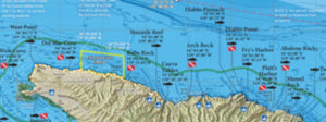
Over 300 Popular Fishing and Diving Spots
Our maps have over 300 GPS numbers listed for the most popular fishing and diving spots along the Orange County coastline, from the Belmont Island Wreck to the Barn Kelp, and all areas in between. Our SoCal Inner Banks map covers SoCal's offshore waters from Pt Dume all the way south to the 302 and Upper Hidden Bank in Mexican waters.
GPS numbers for over 300 popular fishing and diving spots along the Orange County coastline are included in The Private Boater's Guide to Orange County, such as: Long Beach Wall, Belmont Is Wreck, Surfside Hardbottom, Sunset Wreck, Izors Reef, Bolsa Chica, West Bubbles, Inside Bubbles, The Cliffs, Huntington Boiler, Pipeline Rocks, Fuve Rocks, Miniature Rock, 1/4 Acre, The BTR, Outside Rig, West Rock, LCI Wreck, East Rock, Barge Rock, Ribbon Kelp, 10&1/2 Spot, East Bubbles, Power Plant, The 108, San Gabriel Canyon, Huntington Beach Artificial Reefs, Trolley Cars, Rock Barge, Old Pipe, New Pipe, Newport Reef, Orange Street, Double Bubbles, Haystack, Newport Canyon, West Jetty Reef, Peninsula Point, Duke's Point, Carnation Cove, Corona Boilers, 2nd Arch, Pelican Pt Reef, Reef Point, Abalone Point, Blue Roof Area, Seal Rock, Dead Man's Reef, Shaws Cove, Monument Pt, Las Brisas, Cleo Street Barge, Laguna Pinnacles, Rock Wall, Treasure Island Reef, Aliso Pipe, The Hospital, 1000 Steps Kelp, Monarch Boilers, Salt Creek, Strands Kelp, Dana Pt Kelp, San Juan Boilers, Dana Barber Poles, Doheny Flats, Poche, Middle Kelp Reef, Clemente Reef, Clemente Seal Rock, Wheeler North Reef, State Park Reef, San Mateo Kelp, Trestles Kelp, The Domes, Long Pipe, Short Pipe, San Onofre Kelp, Box Canyon, Patterson Kelps, Yellowtail Kelp Barn Kelp, 12-Foot Rock and much more!