San Diego Offshore / N Baja Offshore
Shipping calculated at checkout
In stock
San Diego Offshore/N Baja Offshore
Due to popular demand, we printed up the two offshore fishing maps in our best-selling Private Boater's Guide to San Diego County and are selling them both in one product! This 2-sided laminated map offers GPS locations for over 100 offshore fishing spots in 1-day range from San Diego Bay and Mission Bay harbors.
Two Maps in One Product
Includes 2 map titles, printed back to back, covering the offshore fishing areas from San Diego and Mission Bay: San Diego Offshore, Northern Baja Offshore.
Boating into Mexico?
We've got the information you need for navigating a private boat into Mexico from San Diego County: the new Biosphere Reserves around the Coronado and Todos Santos Islands, the 12-mile and 50-mile boundaries that delineate visa, passport, boat importation permit and Mexican fishing license requirements, as well as the International Border. Also included are boating tips and fishing regulation summaries from CONAPESCA printed right on the map. All Mexico boating information is overlaid on top of popular offshore fishing spots, giving you an "at-a-glance" reference. Fish in Mexican waters with confidence!
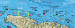
Over 100 Popular Offshore Fishing Spots
GPS numbers listed for over 100 popular offshore fishing spots accessed out of San Diego County harbors, including: the 9-mile Bank, the 101, 181, 182, 425, The Corner, Upper Cross, Upper Finger Bank, Hidden Bank, Banda Bank, Upper 500, Tanner Bank, Cortes Bank, Butterfly Bank, San Salvador Knoll, the 302, 43 Fathom Spot, Sixty Mile Bank, 1010 Trench, Double 220, Dumping Grounds, Bell Bank, The Worm, Mushroom Bank, The Airplane, 213, 1067 Knuckle, 295, 270, 238, Lower 500, Peanut Bank, 1140 Finger, the 230, the 400, The Sniffer, Lower Cross, the Colonet High Spot and much more!