San Nicolas Is / Santa Barbara Is
Shipping calculated at checkout
In stock
San Nicolas Island / Santa Barbara Island
San Nicolas Island and Santa Barbara Island are known by fisherman and divers throughout Southern California for their isolation and big fish. These southern Channel Islands are not easy to get to and a lack of all-weather anchorages makes overnight visits a challenge. Those who do venture from ports in Los Angeles and Orange County need to make the most of their brief opportunity. Game plan efficiently and choose your spots wisely with our laminated fishing map, with all the information you need available at just a glance!
Two Maps in One!
Includes 2 map titles, printed back to back:
- San Nicolas Island
- Santa Barbara Island
Navy Restrictions at San Nic
San Nicolas Island is owned by the US Navy and has various rules and regulations a private boater must follow: a 300-yard buffer around the island closed to vessel entry, Restricted Areas A, B, C that close intermittenly to vessel traffic for military excercises, and a Restricted Anchorage at the East End of the Island. We have all the information you need to navigate around these restrictions, printed right on the map!
Local Boating Knowledge at SBI
Santa Barbara Island is owned by the National Park Service and is open to the public to landing on the island. Facilities include a campground, Visitor Center and hiking trails. We print landing procedures and emergency contacts right on the map to make your visit as simple as possible.
Fishing Regulation Boundaries
San Nicolas and Santa Barbara islands are inside the Cowcod Conservation Area and are open to bottom fishing inside the 40 Fathom depth limit as of 2022. We have the 40 Fathom boundary and GPS waypoints printed right on the map so you can see which bottom structure is open to fishing and which isn't.
Fishing Habitat
White sea bass, yellowtail, calicos, halibut, lingcod, rockfish, lobster...our maps show the fish-holding habitat that an angler fishing the Islands needs to know about: rocky reefs, kelp, shipwrecks and boiler rocks. Find new fishing spots on the water using our calibrated GPS grid and the fishfinder on your boat.
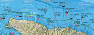
Over 40 Popular Fishing & Diving Spots
GPS numbers listed for over 40 popular fishing and diving spots at Santa Barbara Island and San Nicolas Island, including: San Nic East End Buoy, East End, Seabass Rock, East End Squid Beds, Airplane Rock, Blockhouse Reef, Three Mile Reef, Alpha Kelp, Thousand Springs, The Boilers, 7 Fathom Reef, Rock Crusher Reef, West End Reef, The Wreck, The Markers, Dutch Harbor, Daytona Beach, SBI's Cat Canyon, Sutil Island, Three Sisters, Signal Boilers, Websters, Caverns, Arch Reef, Elephant Seal Cove, Shag Rock, Arch Point, Landing Cove, Ranger Point, Cave Canyon Squid Beds, Sea Lion Rookery, SE Reef and much more!