Laguna Coast / South Orange County
In stock
Laguna Coast / South Orange County
This 2-sided laminated map shows the GPS locations of popular fishing and diving spots of the Orange County coastline between Newport Harbor and Dana Point.
Two Maps in One!
Includes 2 map titles, printed back to back: Laguna Coast and South Orange County, both also found in our Private Boater's Guide to Orange County.
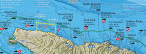
Side 1 of this laminated map covers the fishing spots along the Laguna Coast between Newport Harbor and Dana Point, an area notoriously covered with Marine Protected Areas. This map will help you sort it all out. There is still plenty of good fishing opportunity at Pelican Point, Reef Point, Salt Creek, and Dana Point. This map features a hi-def map of the popular diving spots in Laguna Beach with shaded relief, hardbottom and kelp data. Also included is a detailed map of the facilities at Dana Point Harbor. This fishing map is current for 2021 with SoCal's 100-Fathom rockfish depth boundary.
Side 2 of this laminated fishing map covers the fishing and diving spots to the south of Dana Point Harbor, from the Barber Poles to the Barn Kelp and out to the Box Canyon rockfish area. Pay attention to the bumps and hard bottom on the deep shelf, there is isolated structure to be found using the calibrated gps grid overlay and your fish finder. Includes inset maps of the Wheeler North and Pendleton artificial reefs. This fishing map is current for 2021 with SoCal's 100-Fathom rockfish depth boundary.
Fishing Habitat
Calico bass, white sea bass, yellowtail, halibut, sculpin, rockfish, lobster...our maps show the fish-holding habitat that an inshore fisherman needs-to-know: bottom composition changes, rocky reefs, coarse sand, kelp, boiler rocks, jetties, wrecks and all with a calibrated GPS grid overlay so you can pinpoint your next favorite honey hole!
Over 100 Popular Fishing and Diving Spots
GPS numbers listed for over 60 popular fishing and diving spots along the Orange County coastline between Newport and Dana Point harbors, including: Corona Boilers, 2nd Arch, Pelican Point Reef, Reef Point, Abalone Point, Blue Roof, Seal Rock, Dead Man's Reef, Shaws Cove, Monument Point, Las Brisas, Cleo Street Barge, Laguna Pinnacles, Rock Wall, Treasure Island Reef, Aliso Pipe, Laguna Kelp Farm, 1000 Steps Kelp, The Hospital, Monarch Boilers, Salt Creek Kelp, Strands Kelp, Dana Pt Kelp, San Juan Boilers, Barber Poles, Doheny Flats, Dana Flats, Poche Reef, Middle Kelp Reef, Clemente Reef, Wheeler North Reef, Clemente Seal Rock, State Park Reef, San Mateo Kelp, San Mateo Point, Trestles Kelp, The Domes, Long Pipe, Short Pipe, San Onofre Kelp, Pendleton Artificial Reef, Box Canyon, Patterson Kelp, Yellowtail Kelp, Barn Kelp, 12-Foot Rock and much more!