Horseshoe Kelp / Palos Verdes
Shipping calculated at checkout
In stock
Horseshoe Kelp / Palos Verdes
This 2-sided laminated map shows the GPS locations of popular fishing and diving spots at the Horseshoe Kelp and Palos Verdes areas of the Los Angeles coastline.
Two Maps in One!
Includes 2 map titles, printed back to back: Horseshoe Kelp and Palos Verdes, both also found in our Private Boater's Guide to Los Angeles County.
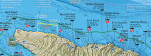
Side 1 of this laminated map covers the fishing and diving spots in the Horseshoe Kelp area from Point Fermin to Queen’s Gate, just minutes from Los Angeles Harbor and Long Beach Harbor. Includes the West End, the Rockpile, Middle Grounds, East End, Jackpot Rock and the 105 areas.
Side 2 of this laminated fishing map covers the fishing and diving spots along the Palos Verdes coastline from King Harbor to Los Angeles Harbor, including Rocky Point, Point Vicente, Point Fermin and all areas in between. Includes inset maps of King Harbor, as well as Hermosa, Redondo and Bunker Point artificial reefs. This fishing map is current for 2021 with SoCal's 100-Fathom rockfish depth boundary.
Fishing Habitat
Calico bass, white sea bass, yellowtail, halibut, sculpin, rockfish, lobster...our maps show the fish-holding habitat that an inshore fisherman needs to know: bottom composition changes, rocky reefs, coarse sand, kelp, boiler rocks, jetties, wrecks and all with a calibrated GPS grid overlay so you can pinpoint your next favorite honey hole!
Smallcraft Harbor Facilities
The names and locations of small craft facilities at LA Harbor, Wilmington, Long Beach Downtown Marina, and Redondo's King Harbor are on the map: marinas, transient mooring areas, public dock access, bait barges, public boat ramps, kayak launches, fuel docks, sportfishing landings, anchorages, waterski areas, swimming areas, 5 mph zones, harbor patrol offices, and much more!
Special Thanks to Capt. Mark Wisch
For a detailed description of many of LA and Orange County's most famous fishing spots and more GPS locations than we could fit on a map, we'd like to give a shout-out to Between Two and Twenty Fathoms by Capt. Mark Wisch. This book is one of the most informative pieces of local fishing knowledge in print today and covers inshore waters from Palos Verdes all the way down the Orange County coast to Dana Point.
Over 150 Popular Fishing and Diving Spots
GPS numbers listed for over 150 popular fishing and diving spots around the Palos Verdes peninsula and the Horseshoe Kelp, including: Hermosa Artificial Reef, Redondo West Wall, the Salad Bowl, Torrance Beach, Palawan Wreck, Malaga Cove, LCM3 Wreck, Haggerty's, Exile Reef, Flat Rock, #1 Spot, Big Reef, Avalon Wreck, Dominator Wreck, Seabass Rock, Rocky Point, Resort Point, Pinnacles, Vicente Bluffs, Barber Pole, Pt Vicente, Pelican Cove, Marineland Reef, Long Point, Portuguese Point, Sacred Cove, Cherry Tree, Bunker Pt Artificial Reef, KOU Rock, 3 Palms Reef, Palms Pipe, Minesweeper Wreck, Whites Pt, Pagoda Rock, Rock Wall, West Kelp, Fermin Reef, 7 Minute Wreck, Two Doors, Green Tank, Sportfisher, Split Rock, Finger Reef, the Rockpile, Atlantis Rock, Lobster Rock, Herb Curleys, High Kel[, Smoke Hole, Bull Kelp, The Triad, Jackpot Rock, Prison Rock, Ace One Wreck, Christmas Rock, White Spot, Yokums, Middle Rock, The IW, Little Cortes, Outside Rock, Inside Rock, Old Southeast, Red Tank Middlegrounds, Georgia Straights Wreck, 13 Fathom Wreck, Ezell's, Southwest Hardbottom, and much more!